Streamline your planning with AfriGIS GISlike
- your customers are
- you need to deliver services
AfriGIS GISlike enables our clients across various government and private industries to adjust their trade areas, sales strategies and decision making processes.
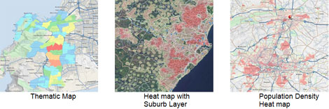
Information is visually displayed on different maps, such as heat maps, immediately indicating areas to be reviewed.
AfriGIS GISlike is an online mapping and analysis application that enables you to streamline your planning and operations by mapping your own data, together with extensive AfriGIS and Census datasets - therefore you can view and analyse your customer data on a map and then adjust or modify your trade areas or maintenance and sales strategies in context of Census and other AfriGIS datasets.

Benefits
- Free online demographic mapping
- Market, consumer and risk profiling
- Market research
- Risk analysis/management
- Trend analysis
- Gap analysis to determine potential business areas
- Municipal asset management
- Powerful simplicity
Try it now:
https://www.afrigis.co.za/solutions/products/evaluate/gislike/
- Sophie Hasell appointed chief revenue officer at AfriGIS 5 Mar 2025
- Helen Hulett appointed as chief sustainability officer at AfriGIS 20 Feb 2025
- AfriGIS appoints Liza Nolte as new business development manager 6 Feb 2025
- Addressing SA’s skills shortage and youth unemployment with IT systems development training 4 Feb 2025
- Leroy Merlin partners with AfriGIS to build SA’s first integrated services marketplace 29 Jan 2025
AfriGISWe create ONE OF A KIND GEOSPATIAL SOLUTIONS. We use geospatial information science to bring information about WHERE to life across industries and in any application. This helps our clients unlock value through better business intelligence. |